Machine learning (ML) based Image Classification in Google Earth Engine (GEE) using Sentinel-2 data OpenGeo Lab 7,77 тыс. подписчиков Скачать
Machine learning (ML) based Image Classification in Google Earth Engine (GEE) using Sentinel-2 data Скачать
Google Earth Engine : Analyse Impact of Heat wave/High Temperature on Crop Growth using NDVI & LST Скачать
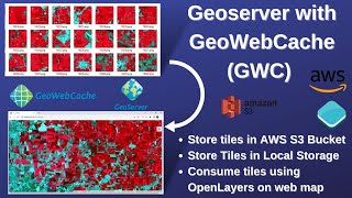
WebGIS: Create fast cached Web Map using Geoserver, GeoWebCache, & AWS (S3 Bucket) as storage medium Скачать
Cloud Optimized GeoTIFF(COG):Create COG, Upload on AWS (S3) Bucket, Access through QGIS & OpenLayers Скачать
Google Earth Engine: Change detection analysis using near real-time Dynamic Global Land cover data Скачать
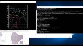
Python for Geospatial Analysis: Install Python, GeoPandas, GDAL and Rasterio library[using pip] Скачать
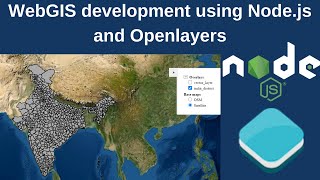
WebGIS Development from scratch using Openlayers/Leaflet & Geoserver with feature query capability Скачать
WebGIS dashboard without any programming/Coding using MapStore framework and Geoserver - part 2 Скачать
WebGIS application development without any programming using MapStore framework and Geoserver-part1 Скачать
Watching the Earth breathe: Seasonal Vegetation Time lapse for the last two decades (2000 to 2021) Скачать
Download Vegetation Health Products (VCI, TCI, VHI) derived from Satellite Remote Sensing data Скачать
Create Fast cached Base Map like Google Map based on OSM data using Postgis, Geoserver & Tilecaching Скачать
Openlayers 6: Styling Vector data (Markers, Choropleth and Proportional Circles map on WebGIS) Скачать
Geoserver: Publish and style raster data in geoserver for WebGIS application using Openlayers 6 Скачать
GIS Animation and Bar race chart of COVID-19 data using Python (geopandas, panadas and matplotlib) Скачать
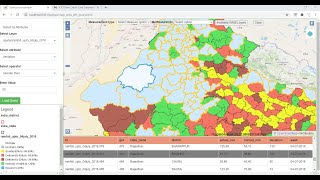
WebGIS app development using Openlayers-6 & Geoserver-Pt3 (Query panel using WMS & WFS service) Скачать
WebGIS application development using Openlayers 6 and Geoserver-part2 (Featureinfo and Measure Tool) Скачать
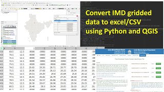
How to download and convert IMD gridded binary weather data to csv/excel using python and QGIS Скачать
WebGIS Application development (feature editing on web)using Geoserver, Openlayers, GeoExt, Postgis Скачать
Add GIS functions to WebGIS page i.e Zoomin, Zoom to extent, Measure, featureinfo etc. - part2 Скачать
Install postgresql with postgis extension and import/export shapefiles from the postgis database Скачать


![Python for Geospatial Analysis: Install Python, GeoPandas, GDAL and Rasterio library[using pip]](http://i.ytimg.com/vi/Z4ySoDNm0ZI/mqdefault.jpg)


![Python for Geospatial Analysis: Install Python, GeoPandas, GDAL and Rasterio library[using pip]](https://i.ytimg.com/vi/Z4ySoDNm0ZI/mqdefault.jpg)


