How to Create Your Account on Google Earth Engine (GEE) Platform Vikas Ghadamode 18,5 тыс. подписчиков Скачать
Download weather data from NASA Power (precipitation, temperature, relative humidity, Wind Speed) Скачать
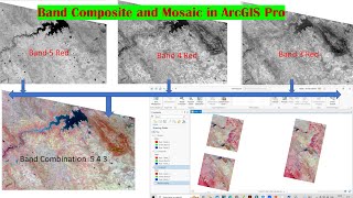
Download False Color Composite, NDVI, NDWI, and NDSI from the Copernicus Data Space Ecosystem Скачать
How to Download Landsat 8 and Landsat 9 Satellite Imagery from Bhoonidhi Portal for whole world Скачать
Download weather data from NASA Power (precipitation, Temp, relative humidity) and Prepare Map Скачать
How to Export a small portion from a Larger Shapefile and create a city center using ArcGIS Pro Скачать
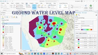
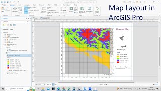
How to Create Average Annual Rainfall Map using ArcGIS Pro (5 Years Average precipitation Map) Скачать
ArcGIS Pro 3 How to download DEM to Prepare Slope, Aspect, Contour and Geomorphic Landforms Maps Скачать
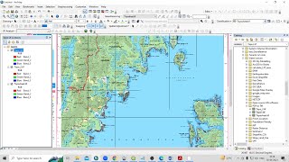
ArcPro 1 Introduction to ArcGIS Pro, Georeferencing and UTM Projection, Absolute beginner guideline Скачать
RS & GIS QA 63 How to Prepare Normalized Difference Snow index (NDSI) and calculate area of Snow Скачать
RS & GIS QA61 How to Convert Multiple PDF file into TIff File using ArcMAP for absolute Beginners Скачать
RS & GIS QA59 Geocode tool that can help you to get latitudes and longitudes for multiple addresses Скачать
RS & GIS QA49 How to Dowload Global Digital Surface Model (DSM) || Difference Between DSM and DEM Скачать
RS & GIS QA48 How to download free latest Sentinel-2 10m LULC Timeseries data from esri application Скачать
RS and GIS QA37 Identifying At-Risk Land Use Areas for Future Floods and Tsunamis using ArcGIS Скачать
RS & GIS QA31 How to Download Slope, Hillshed, Aspect, Relief and Roughness Map (Open Topography) Скачать
RS & GIS QA29 How to Use Google Maps and Google earth for Point of Interest (POI) data Generation Скачать
RS & GIS QA26 Validation of LULC in ARCGIS using the Accuracy Assessment and Confusion Matrix tools Скачать
RS & GIS QA13- How to calculate the altitude of any place? Find Elevation from Latitude & longitude Скачать
RS & GIS QA6- How to get all pixcel values from a raster image||prepare Rainfall map from point data Скачать
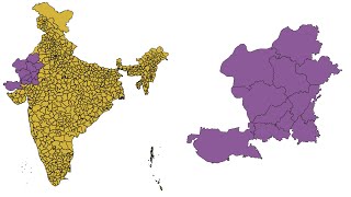
RS & GIS QA5 Download Free India State, District, taluka Shapefile with Jammu, Kashmir, and Ladakh Скачать
RS & GIS QA1: How to Create Watershed using pour point || Delineation of watershed using pour point Скачать
Google Earth Timelapse- See how our planet has changed since 1984 | Earth Timelapse video downloads Скачать
How to calculate Minimum, Maximum and Mean LST (°C) for different land use land cover classes Скачать
How to find Longest Flow path of the River Basin || Calculate the Length of the Logest flow path Скачать
Land Use / Land cover (LULC) change detection of Landsat 8 || Land use change Area calculation Скачать
Land Use Land Cove (LULC) Mapping using QGIS || Landsat 8 Calssification using QGIS, Language Hindi Скачать