How to Shift And Offset Of DEM Image Raster Data X and Y Point With Out Changing Altitude On ArcgIs Скачать
NDSI (Normalized Difference Salinity Index) of Malaysia Coastline Of Landsat 8 Data ][ On ArcgIs Скачать
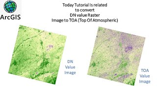
How to (TOA) Top Of Atmospheric Correction of Landsat 8 Data ‖ By ArcGis ‖ Raster Calculator Tool Скачать
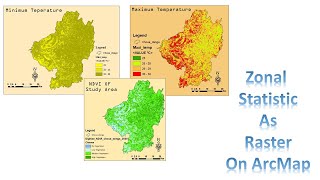
ZONAL STATISTIC Tool Use AS RASTER ‖ To Find Max & Mini Temperature ‖ As compare To NDVI Data Скачать


![How To Make Shore line with Help Of Tasseled Cap Tool ][ On ArcGis](http://i.ytimg.com/vi/b0Q_AhUUcWQ/mqdefault.jpg)
![NDSI (Normalized Difference Salinity Index) of Malaysia Coastline Of Landsat 8 Data ][ On ArcgIs](http://i.ytimg.com/vi/ZfrBxSEkKsQ/mqdefault.jpg)


![How to find Lst of landsat 8 or 9 Data ][ By Arcgis](http://i.ytimg.com/vi/7xt_ibpyHVM/mqdefault.jpg)


![Global night View From Qgis With Tiles+ Plugins ][ link of Pulgin in description](http://i.ytimg.com/vi/cVz7MuYkiKo/mqdefault.jpg)
![lineament and Lineament density finding Through DEM Data On ArcGis [] Arcmap Of Any Part](http://i.ytimg.com/vi/XQqggaNZPCI/mqdefault.jpg)

![open topography Website [] How To download DEM / DSM Data OF 30 /90 meters Resolution](http://i.ytimg.com/vi/9AGdoLOl9R0/mqdefault.jpg)


![How to Restore Attribute table ][ On ArcMap](http://i.ytimg.com/vi/dq5PRkqiASg/mqdefault.jpg)


![PSRI index With Landsat 5 Data ][ On ArcMap #arcgis](http://i.ytimg.com/vi/Fvl77c7Wsio/mqdefault.jpg)

![BSI (Bare Soil Index) Of #landsat 8 Data ][ Using #remote_sensing On #arcgis #arcmap](http://i.ytimg.com/vi/AGcqnDN2DNk/mqdefault.jpg)


![How To Make Shore line with Help Of Tasseled Cap Tool ][ On ArcGis](https://i.ytimg.com/vi/b0Q_AhUUcWQ/mqdefault.jpg)
![NDSI (Normalized Difference Salinity Index) of Malaysia Coastline Of Landsat 8 Data ][ On ArcgIs](https://i.ytimg.com/vi/ZfrBxSEkKsQ/mqdefault.jpg)


![How to find Lst of landsat 8 or 9 Data ][ By Arcgis](https://i.ytimg.com/vi/7xt_ibpyHVM/mqdefault.jpg)


![Global night View From Qgis With Tiles+ Plugins ][ link of Pulgin in description](https://i.ytimg.com/vi/cVz7MuYkiKo/mqdefault.jpg)
![lineament and Lineament density finding Through DEM Data On ArcGis [] Arcmap Of Any Part](https://i.ytimg.com/vi/XQqggaNZPCI/mqdefault.jpg)

![open topography Website [] How To download DEM / DSM Data OF 30 /90 meters Resolution](https://i.ytimg.com/vi/9AGdoLOl9R0/mqdefault.jpg)


![How to Restore Attribute table ][ On ArcMap](https://i.ytimg.com/vi/dq5PRkqiASg/mqdefault.jpg)


![PSRI index With Landsat 5 Data ][ On ArcMap #arcgis](https://i.ytimg.com/vi/Fvl77c7Wsio/mqdefault.jpg)

![BSI (Bare Soil Index) Of #landsat 8 Data ][ Using #remote_sensing On #arcgis #arcmap](https://i.ytimg.com/vi/AGcqnDN2DNk/mqdefault.jpg)


