UPDATE: January 2024
Our drone mapping course is free of charge to all who are interested. It does cost us to have it online so if you can donate to help offset the cost, Please do.
[ Ссылка ]
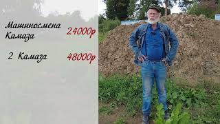
You will be surprised to find out how different the results are when using a drone to map contour lines. This video shows the difference between using ground control points #GCPs and not using them. You need to watch this video if you are not sure if you need Ground control.
#photogrammetry