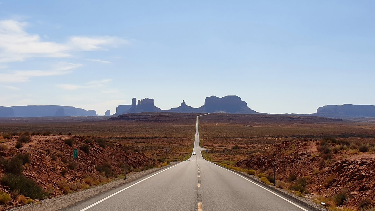
Part of our Grand Circle Tour of American Southwest. This episode shows Monument Valley Navajo Tribal Park and the iconic Road on US Highway 163 to Oljato Monument Valley.
Welcome to U.S. Highway 163 and sea also our Video of Mexican Hat, Utah.
Approaching the iconic Road to Monument Valley and entering Monument Valley Navajo Tribal Park.
West Mitten Butte (which may be seen close up via the 3.2 mile Wildcat Trail), Merrick Butte and East Mitten Butte. On the right side of the road, the flat land is bordered by the eastern face of Mitchell Mesa.
The Three Sisters are a group of thin pinnacles, eroded remnants of a narrow ridge extending southwards from one corner of Mitchell Mesa - together with adjoining Wetherill Mesa these two flat-topped hills shield this part of Monument Valley from US 163 further west. There are several similar groups of spires elsewhere in the valley including Castle Rock, and Bear and Rabbit, a few miles north near Monument Pass.
Film director John Ford used Monument Valley as a location for many Westerns between 1939 (Stagecoach) and 1960, and one site that featured often is now known as John Ford's Point - a promontory at the edge of a plateau overlooking a large area of uneven, undulating desert land around the first few miles of the Valley Drive, with several isolated peaks beyond. The main summits in view are Sentinel Mesa, West Mitten Butte, Big Indian, Merrick Butte and the Castle Rock-Stagecoach group, plus Three Sisters/Mitchell Mesa to the west and Elephant Mesa to the east (see 360 degree panorama). Along with Artist's Point (viewpoint number 9), this is the best overlook in the park and has a suitably large parking area to accommodate the many tour buses that stop here. A permanent Navajo jewelry store is located nearby, and visitors can recreate the iconic image of a lone rider on a horse standing at the edge of the viewpoint for just $2 per person - paid to the owner of one of the horses stationed here most of the day just for this purpose.
The Hub
The next junction is reached 1.3 miles from the crossroads, where the main route bears east and enters a more confined valley between Rain God Mesa and Thunderbird Mesa. The other track leads to places in the south of the tribal park including Saddle Rock, Submarine Rock, Totem Pole, several sandstone arches, Anasazi dwellings and petroglyphs, though this section may only be visited on an escorted tour. A little way southwest of the junction, The Hub is a single, solitary spire, 150 feet high, with a cluster of Navajo dwellings at its base. There are no rocks beyond this for about 4 miles, as far as Hunts Mesa which forms the southern boundary of Monument Valley.
Totem Pole and Yei Bi Chei
The one-way loop road continues close to Rain God Mesa through increasingly sandy ground; large dunes rise up to the south, in front of the larger Thunderbird Mesa, and a shallow wash (Sand Spring, the main water source in the area) runs alongside. At the edge of the sands is another isolated group of spires (Yei Bi Chei) next to which stands one of the most well known peaks in the valley. Totem Pole is a tall, red sandstone column, 450 feet high but only 40 foot across, slightly detached from its neighbors, and pointing skywards against a backdrop of wide but more distant cliffs of the Tse Biyi Yazzie and Hunts Mesa formations. The pinnacles are quite far from the viewpoint (one mile) so not easy to photograph in detail. A closer view is possible from other tracks further south, which form part of the extended guided tour across the southern half of the park.
Totem Pole and Sand Spring
The next pull-out is officially a viewpoint of Sand Spring and the nearby red-orange dunes but it also gives a better perspective of Totem Pole and Yei Bi Chei. The parking area is along a side track that branches off at the south end of Spearhead Mesa, a route that continues across a creekbed (Gypsum Wash) and on to the southern section of the park, off-limits to private vehicles. Spearhead is a multi-pointed mesa that borders the main road for a mile northwards, as far as Artist's Point.
Artist's Point
This is Artist's Point, perhaps the second best overlook along the drive (after John Ford's Point), but one rather less visited and so more peaceful. The edge of Spearhead Mesa towers quite high above to the east, and to the west are the smaller spans of Cly Butte and Elephant Butte
North Window - a gap between the edges of Elephant Butte and Cly Butte which frames East Mitten Butte, 3 miles to the north.
The Thumb
The last recognized overlook along the Valley Drive is next to The Thumb, a rounded pinnacle at the eastern tip of Camel Butte, close to the parking area for North Window. Not far beyond, the Valley Drive arrives back at the crossroads near John Ford's Point, from where the visitor center is 3.5 miles north.


![Я нашел НОВЫЙ НЕОБИТАЕМЫЙ ОСТРОВ и ОСТАЛСЯ там ЖИТЬ. ВЫЖИВАНИЕ [Часть-1]](https://s2.save4k.ru/pic/jUE83uHhmqA/mqdefault.jpg)


![🇲🇽 Cancún to Paris CDG 🇫🇷 Air France Boeing 777 [FULL FLIGHT REPORT] Economy Class](https://s2.save4k.ru/pic/qZe72DzuMpU/mqdefault.jpg)


![[BTS]💜On Jimin's birthday, at Jimin's dad's cafe / 1013 JIMIN DAY Jimtober MAGNATE - Korea Walk Tour](https://s2.save4k.ru/pic/15yxIiUCAaM/mqdefault.jpg)