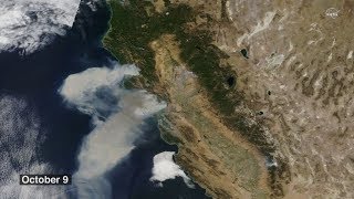
As wildfires burn across California, NASA satellites help gather data about where the fires are and how smoke travels across the state.
The smoke from the fires is even visible a million miles away from Earth, captured by NASA's Earth Polychromatic Imaging Camera (EPIC) onboard NOAA's Deep Space Climate Observatory (DSCOVR).
The Terra spacecraft can see fires in both daylight and at night, helping aid firefighters in tracking and stopping the blazes.
NASA's unique vantage point in space helps better understand our home planet.
Terra Imagery from NASA Worldview: [ Ссылка ]
Music: Seven by Andrea Sacco [SACEM]
This video is public domain and along with other supporting visualizations can be downloaded from the Scientific Visualization Studio at: [ Ссылка ]
Credit: NASA's Goddard Space Flight Center/Kathryn Mersmann
If you liked this video, subscribe to the NASA Goddard YouTube channel: [ Ссылка ]
Follow NASA’s Goddard Space Flight Center
· Facebook: [ Ссылка ]
· Twitter [ Ссылка ]
· Flickr [ Ссылка ]
· Instagram [ Ссылка ]
· Google+ [ Ссылка ]


![Винкс Клуб - Винкс Клуб - Сезон 1 Серии 7 - 8 - 9 [ПОЛНЫЕ СЕРИИ]](http://i.ytimg.com/vi/izO-EYTm0Bc/mqdefault.jpg)