In this video I have discussed the methods of how to collect field survey data in surveying by using your mobile phone GPS service.
Best offer Today: [ Ссылка ]
√[Note: This method is not recommended for Precision Surveying]
This method can be used for measurement of an Area approximately.
SUBSCRIBE us (its free)
[ Ссылка ]
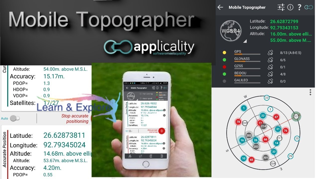
Mobile Topographer application download link
[ Ссылка ]
Your mobile Topographer!
The leading tool for the professional surveyor or anyone who wants to mark his property, offering the best accuracy and extensive functionality that no other app can!
*** Increase GPS accuracy using:
- Weighted averaging (on every axis).
- Map calibration.
- Device calibration on map, or on a know point.
*** Auto stop for accurate positioning.
*** Examine the satellites above you in a sky view.
*** Signal strength and number of satellites indication for each GNSS constellation individually.
*** Multiple units support:
- Meters,
- International feet,
- US survey feet.
***Height calculation:
- Ellipsoidal height.
- EGM96 orthometric height calculation.
*** Convert from geodetic to Cartesian coordinates and back:
- Support for device measured points, or
- Manually input of geodetic or Cartesian coords.
*** Drive me:
- Key in coordinates of the target point in either geodetic or Cartesian coordinates, or select a point from the list and follow the pointer.
- Compass indicating both magnetic and true North.
*** Project on Map:
- Project individual points on any map application.
- Project list of points, and the defined polygon, on embedded maps.
*** Save multiple point lists, to use them later.
*** Calculate area.
*** Export point lists το:
- .txt (text file)
- .csv (point file - comma separated)
- .kml (google earth file)
- .gpx (Gps Exchange format)
- .dxf (drawing file)
l
PTS format creation download link
[ Ссылка ]
watch more tutorials related to AutoCAD and Excel:
(How to import Points/X,Y Co-ordinates)
[ Ссылка ]
(How to import Lines from excel to AutoCAD)
[ Ссылка ]
(How to import Texts from excel to AutoCAD)
[ Ссылка ]
How to convert Lat, Long to UTM (Easting,Northing) | by QGIS Software (English)
[ Ссылка ]
Bearing and Distance Calculation from Easting, Northing | Excel | Download Link Inside
[ Ссылка ]
If you think this tutorial is helpful please SUBSCRIBE Like & Share this video and Subscribe our channel to get free updates
With best wishes
SUBSCRIBE (its free)
[ Ссылка ]
L&E Team!