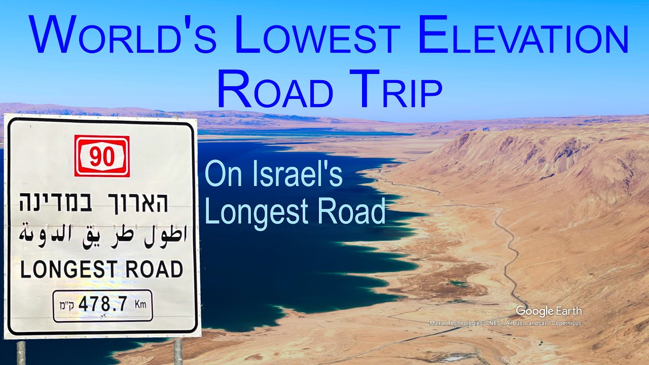
The world’s lowest elevation road trip (up to 427 meters below sea level), driving on Israel’s longest road, Highway 90.
A complete end-to-end road trip driving timelapse (hyperlapse) on Israel longest road, Highway 90. From Metula, at the border between Israel and Lebanon in the north, along the Jordan Valley and the border between Israel and Jordan, to the Israel and Egypt Taba border crossing in the south.
A continues300 km long segment of this road trip was below sea level, mostly between elevations of -200 to -430 meters, making it the lowest road trip on earth.
This entire trip was completed within a single day.
Subscribe to the channel:
[ Ссылка ]
I'm hiking ultralight. Listed below is my primary hiking gear and photography gear.
The primary photography gear includes (** used for this video):
** GoPro Hero 9 (Amazon affiliate link), [ Ссылка ]
GoPro Max lens (Amazon affiliate link), [ Ссылка ]
** DJI Mavic 3 drone (Amazon affiliate link), [ Ссылка ]
Olympus OM-D E-M5 Mark III (Amazon affiliate link), [ Ссылка ]
** iPhone 12 Pro Max (Amazon affiliate link), [ Ссылка ]
SmallRig iPhone case (Amazon affiliate link), [ Ссылка ]
Peak Design Cuff Camera Wrist Strap (Amazon affiliate link), [ Ссылка ]
Nitecore NB10000 Ultralight Power Bank (Amazon affiliate link), [ Ссылка ]
My primary hiking gear includes (** used in this hike):
Black Diamond Alpine Carbon Cork Trekking Poles (Amazon affiliate paid link): [ Ссылка ]
Black Diamond Z-folding Carbon Trekking Poles (Amazon affiliate paid link): [ Ссылка ]
Salomon running vest (Amazon affiliate paid link): [ Ссылка ]
Nike Pegasus Trail 3 (Amazon affiliate paid link):[ Ссылка ]
Salomon Speedcross 5 GTX (Amazon affiliate paid link): [ Ссылка ]
DISCLAIMER: Links included in this description might be Amazon affiliate links. If you purchase a product or service with the links provided I may receive a small commission, but without any additional charge to you.
The hyperlapse was shot with a GoPro Hero 9, mounted externally on the car.
This video also includes drone shots taken with a DJI Mavic Pro, and a few sequences taken with an iPhone 12 Pro Max.
A Google Earth satellite imagery of the complete rout is provided at the end of this video.
Music, by multiple composers. Available at UppBeat:
[ Ссылка ]
Satellite imagery was rendered using Google Earth Studio.
#Israel
#road-trip
#time-lapse
#desert-road-trip
Eilat
Metula
Sea-of-Galilee
נסיעה ממטולה לאילת על כביש 90
כנרת
הגדר הטובה
בית שאן
בקעת הירדן
קומרן
ים המלח
מצדה
עין גדי
עין בוקק
קטורה
צומת 101
תמנע
אילת
טאבה