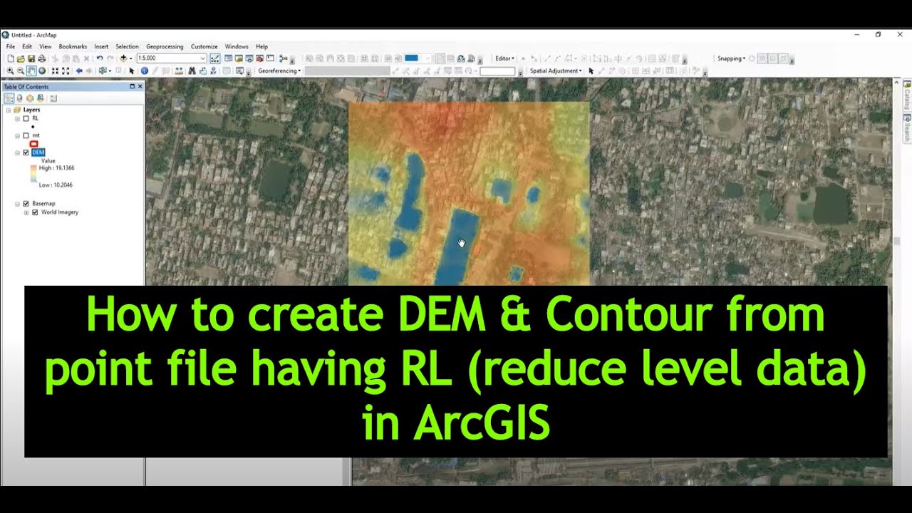
In this tutorial, I'm going to show you how to create DEM & Contour from Point file (Having RL Value) or Spot Level Data
#exploretutorials #DEMcontour #arcgisgoogle_earcth
Free Spatial Data |Shapefile| of Any Country & Humanitarian Data: [ Ссылка ]
Land Cover Data 10 m Resolution: [ Ссылка ]
Least Cost Path: [ Ссылка ]
Download Open street Map: [ Ссылка ]
Stream Power Index SPI Calculation:[ Ссылка ]
Topographic Wetness Index TWI Calculation: [ Ссылка ]
Suitability Analysis Using Arcgis: [ Ссылка ]
Add xy data from excel, clip, select, split, table select tools in ArcGIS: [ Ссылка ]
Drainage or Stream Frequency & Infiltration number: [ Ссылка ]
Calculate Stream or Drainage Density: [ Ссылка ]
Extracting Stream or Drainage Network from DEM: [ Ссылка ]
Detail Watershed Delineation using DEM: [ Ссылка ]
ArcGIS Tutorial:[ Ссылка ]
Qgis Tutorial: [ Ссылка ]
Change Detection: [ Ссылка ]
Download Free Shapefile:[ Ссылка ]
Download Soil Organic Carbon, Evapotranspiration, Land cover, Precipitation Data: [ Ссылка ]
Human Influence Calculation: [ Ссылка ]
Lineaments Extraction :[ Ссылка ]
World Soil Map Shapefile: [ Ссылка ]
Hotspot / Kernel Density Analysis: [ Ссылка ]
GIS Shapefile Data ( Road, Structure, etc.) for Any Country: [ Ссылка ]
Land Cover Change Detection: [ Ссылка ]
Soil Moisture Index and Land Surface Temperature Calculation: [ Ссылка ]
Calculate normalized burn ratio (NBR): [ Ссылка ]
Create Specific & Random Points: [ Ссылка ]
Keyword: Arcgis Tool,DEM,Digital Elevation Model,Contour,RL value,GIS tutorial,how to create dem from contours in qgis,contouring in surveying pdf,how to draw contour lines surveying,how to draw contour lines in block levelling,contour survey,interpolating contours graphically,qgis tutorial,dem,contour,arcgis,shapfile,10.3,point,digital elevation model,point to dem,point to contour,


![В гостях у Рыжкина: Азат Нургалеев [основатель SKILLS UP: школы рисунка и цифровой графики] #5](https://s2.save4k.ru/pic/eeX1d3rnTCs/mqdefault.jpg)

![Как лепить ПОРТРЕТ? Часть 5. [СКУЛЬПТУРА] - А. Рыжкин](https://s2.save4k.ru/pic/5bKh30vm5Fc/mqdefault.jpg)

![Песня волшебника - Музыкальное Вскрытие [из к/ф "Обыкновенное Чудо"]](https://s2.save4k.ru/pic/aVKjDUGSQVA/mqdefault.jpg)
![В гостях у Рыжкина: Симона Ершова [художник-иллюстратор, YouTube-блогер @SIMARTART] #1](https://s2.save4k.ru/pic/HfdZ9VSp64k/mqdefault.jpg)


![Как лепить ПОРТРЕТ? Часть 4. [СКУЛЬПТУРА] - А. Рыжкин](https://s2.save4k.ru/pic/_DNKXbQmmn0/mqdefault.jpg)