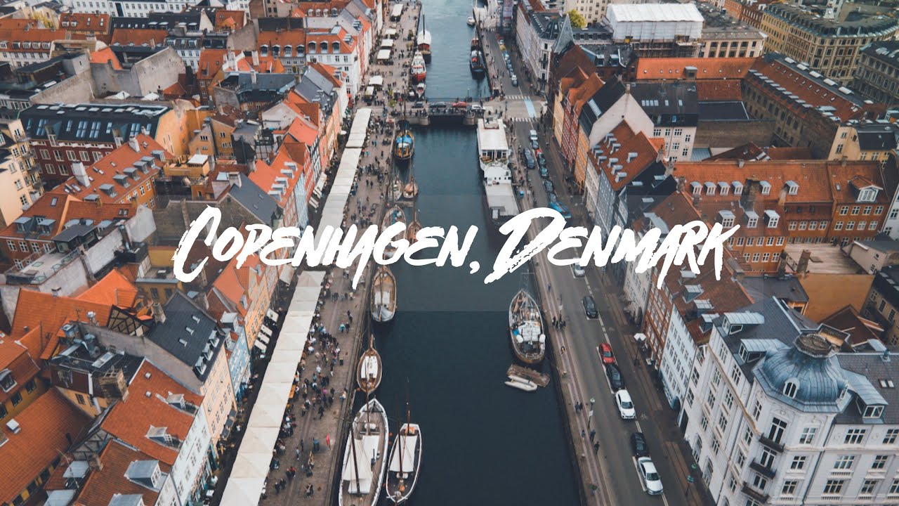
This drone video is from flights I took my 2nd time in the Danish capital. I had spent a few days in Denmark already, seeing other cities like Aarhus and Odense, before eventually reaching Copenhagen to greet my parents and officially welcome them to Europe.
Copenhagen is also the largest city in Denmark and sits across the Öresund sound from the Swedish city of Malmö. There is plenty to see and do in this city and great sights including but not limited to Nyhavn Harbor, Frederik's Church, St. Alban's Church, Kastellet, Danish Royal Library Gardens, Rosenborg Palace, Amalienborg Palace, NY Carlsberg Glyptotek, Tivoli Gardens, Christiansborg Palace, Little Mermaid Statue, and the town of Christiania.
For more information on my trips to Copenhagen, be sure to check out my blog post below:
[ Ссылка ]
Be sure to check out my other youtube videos on spots in Denmark below:
Copenhagen - [ Ссылка ]
Odense - [ Ссылка ]
Aarhus - [ Ссылка ]
Unfortunately, given just how congested Copenhagen is in terms of sensitive infrastructure, you are quite limited in regards to the suitable locations you can fly your drone. For instance, most overflights that I conducted were over waterways (usually canals and harbors). On land, flights were mostly performed over Christianshaven, which is outside the Copenhagen airport control zone as well as the infrastructure zones in the Copenhagen city center. Therefore, this video is not as comprehensive as it could be with regards to what to see in Copenhagen however I hope this gives you a glimpse of what this city has to offer, from the air (Check out the link further below for a drone map of Denmark, showing you what areas are ok to fly in).
Drone laws in Denmark: In order to fly your drone in Denmark, you should have a A1/A3 certification in the OPEN category in any EU member state (I have one from Sweden). This allows you to fly (under certain restrictions) within other EU countries. The standard rules apply such as flying within visual line of sight, not flying at night, only 120 meters in elevation, and not over crowds or sensitive infrastructure. Furthermore, other restrictions may also be enacted by the Danish Transport Authority. I used their official drone map on their website to plan my overflights beforehand. You can find the map here: [ Ссылка ]
Check out my social media channels and travel blog for more travel inspiration:
My Blog: [ Ссылка ]
Facebook: [ Ссылка ]
Pinterest: [ Ссылка ]
Instagram: [ Ссылка ]
Twitter: [ Ссылка ]
Etsy Prints: [ Ссылка ]
Kit: DJI Mavic Air 2
Program: Final Cut Pro

![STARSCAPES [4K] Stunning AstroLapse Ambient Film with Space Music for Deep Relaxation & Sleep](http://i.ytimg.com/vi/CrgYEbIQkac/mqdefault.jpg)


![[S2 - Eps. 46] Caught in a hail storm at 4700 meters altitude in the Andes!](http://i.ytimg.com/vi/eGtgGH867Ls/mqdefault.jpg)


![[S2 - Eps. 64] Che Guevara was EXECUTED right here..](https://i.ytimg.com/vi/W3H7-bXn-Ug/mqdefault.jpg)


![🇺🇸 New York JFK - Paris CDG 🇫🇷 Air France Airbus A350 New Cabin ! [FULL FLIGHT REPORT]](https://i.ytimg.com/vi/Wz37kLniiC4/mqdefault.jpg)


![[S2 - Eps. 35] A tragedy happened here - To Futaleufu, Chile by Motorcycle](https://i.ytimg.com/vi/gCHOLox1U6g/mqdefault.jpg)


![[S2 - Eps. 68] ESCAPING more destructive rain in BOLIVIA!](https://i.ytimg.com/vi/1jp_3z5dxWI/mqdefault.jpg)