Get your 3 months free here: [ Ссылка ] or use the discount code davidtomic. Thank you to Zyro for sponsoring today’s video.
Architect Essentials:
►Digital Downloads: [ Ссылка ]
►Architect Merch: [ Ссылка ]
Community:
►Free Discord Group Chat: [ Ссылка ]
►All Access ArchiCAD Files: [ Ссылка ]
The best shirt ever:
►CUTS Clothing: [ Ссылка ]
Socials:
►Follow me on Instagram: [ Ссылка ]
►Follow me on Twitter: [ Ссылка ]_
►Don't forget to LIKE this video for the YouTube Algorithm!
VIDEO DETAILS:
Today we review how you can take a 3D lidar scan from an M1 iPad pro and convert it into a workable site mesh on archicad.
Who would have thought that technology would have advanced so much that we could literally take our iphone/ipad and scan the entire world! The m1 ipad pro makes this video possible.
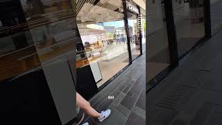
By using the app SCANIVERSE we can walk on a site, scan the entire area and create a 3D model of that site.
Then by exporting an STL file directly from scaniverse (this is a premium feature which you will have to upgrade too, but don’t worry they have a 7 day free trail which allows you to access all of these premium features without paying, just make sure you cancel your subscription rather quickly after youre done) we have the ability to import the file directly into archicad and create an site mesh that will form the basis of any architectural design.
Note: archicad does struggle with the STL files as there are millions of polygons in this file, thus it may case some systems to lag or crash. Even on a high end, custom built pc, this process was a challenge.
00:00 Intro
00:23 Scanning
03:00 Importing
04:05 Orientating
06:42 Video Sponsor
09:45 Mesh Building
14:44 Outro