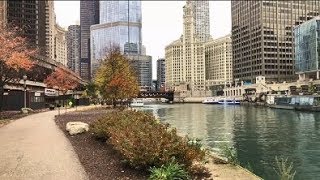
The Chicago Riverwalk is an open, pedestrian waterfront located on the south bank of the main branch of the Chicago River in downtown Chicago. It spans from Lake Shore Drive to Lake Street. Called the city's 'Second Lakefront', the Riverwalk contains restaurants, park-seating, boat rentals, and other activities.
In conjunction with the Chicago Department of Transportation, construction of the Riverwalk began in 2001. With the rebuilding of Wacker Drive, the street was purposely relocated to allow for development of the walk. The oldest section now called Market, between Lake Shore Drive and Michigan Avenue was at first an extension of the lake shore trail with tour boat docks, concessions and stair access. Sections at first required going up to street and bridge level to access the next section, until design plans and funding could be arranged over time.
The plan developed by architects at Skidmore, Owings and Merrill called for four separate districts within the riverwalk: Confluence, Arcade, Civic and Market, all with a specific location and theme in mind.
Confluence: Located where the Main, North and South branches of the River intersect. Previously the location of taverns, hotels and convention centers, it is now a major intersection of not only the River but the neighborhoods that border it. This area of the Riverwalk was expanded fifty feet into the river for the installation of park space and pedestrian access to Upper Wacker Drive as well as various amenities located in this area.
Arcade: The District spanning east from Franklin to State Street. It is called the "Arcade" because of the architectural detailing that separates the riverfront from the rest of the Wacker Drive.
Civic: The District spanning east from Dearborn St. to Michigan Ave. It includes the Chicago Bridgehouse Museum, located at Michigan Ave. and Wacker Dr., and is also the focal point for visitor and tourist activities, primarily for the boat launches. The Trump International Tower and Hotel is also located along this stretch of the Riverwalk, as well as notable landmarks such as the Wrigley Building and the Tribune Tower.
Market: The District spanning from Columbus Dr. (including Stetson St.) east to Lake Shore Drive. Location of Chicago's First Lady boat launch as well as a beautifully landscaped space that contrasts with the other districts while walking east towards the lakeshore. This area also includes a restaurant, Cyrano's and a residential community: Lakeshore East.
On October 8, 2012, Mayor Rahm Emanuel unveiled plans for an addition to the Riverwalk, extending it another six blocks along Chicago's River from State to Lake streets.
In June 2015, The Marina Plaza, The Cove, and The River Theater sections of the Riverwalk from State Street to LaSalle Street was officially opened.
The City has been working on the development plan for the Chicago Riverwalk since the 1990s. During the reconstruction of East-West Wacker Drive, the roadway was reconfigured to allow greater public access to the river. The City received Congressional approval to redefine the navigational channel allowing the build-out of the path 20 feet under each bridge and 25 feet between each bridge and 50 feet between Franklin and Lake Street in order to extend the Riverwalk.
The City obtained $98 million for design engineering and construction from the U.S. Department of Transportation through the Transportation Infrastructure Finance and Innovation Act). The remaining phase along the south bank of the river from Lake Street to State Street will connect to the previously completed section of the Riverwalk.
In October 2016, The Water Plaza, The Jetty, and The Boardwalk sections from LaSalle Street to Lake Street opened to the public.[15]
The city is planning a $10M renovation of the Riverwalk east of State Street. The oldest section of the walk, Riverwalk East will see improvements like new landscaping, seating, play areas, and walkways.