"Imago Mundi" refers to a Latin term that translates to "Image of the World" in English. Historically, it has been used to describe maps, atlases, or representations of the world, often with a focus on geographical and cartographic elements. One notable example is the "Imago Mundi" project initiated by the ancient Babylonians, where they created one of the earliest known world maps on a clay tablet.
In a broader sense, "Imago Mundi" can also be used metaphorically to convey a comprehensive and symbolic representation of the world or universe in various contexts, including art, literature, and philosophy. The term encapsulates the human endeavor to understand, visualize, and depict the world in its entirety, reflecting cultural, scientific, and artistic perspectives throughout history.
Certainly, here's more information about "Imago Mundi":
1. **Historical Significance:**
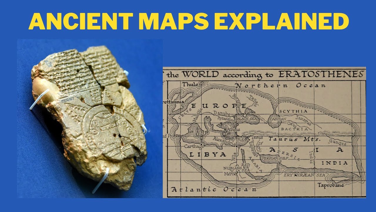
- **Babylonian Imago Mundi:** The Babylonian World Map, dating back to the 6th century BCE, is one of the earliest known examples of an "Imago Mundi." It was inscribed on a clay tablet and represents a simplified, circular depiction of the known world at the time.
2. **Cultural Representations:**
- **Medieval Mappa Mundi:** In medieval Europe, "Mappa Mundi" (Maps of the World) were created, often housed in churches. These maps combined religious, mythological, and geographical elements, with Jerusalem typically placed at the center.
3. **Artistic and Literary References:**
- **Jorge Luis Borges' "On Exactitude in Science":** In Borges' short story, he describes an empire that creates a map so detailed that it perfectly mirrors the territory it represents, highlighting the impossibility of achieving a perfect "Imago Mundi."
4. **Contemporary Projects:**
- **Imago Mundi Art Project:** The contemporary art project initiated by the Luciano Benetton Collection, "Imago Mundi," invites artists from around the world to create small-scale works that reflect their cultural and artistic identities. The collection aims to build a visual atlas of the world through art.
5. **Metaphorical Usage:**
- **Philosophical Reflections:** The term "Imago Mundi" is sometimes used in philosophical discussions to represent the mental and conceptual image individuals or societies have of the world, encompassing beliefs, perspectives, and cultural frameworks.
6. **Global Perspectives:**
- **Diversity of Worldviews:** The concept of "Imago Mundi" underscores the diversity of worldviews across different cultures and periods, emphasizing that the representation of the world is subjective and shaped by cultural, religious, and scientific paradigms.
7. **Digital Mapping and Technology:**
- **Modern Cartography:** With advancements in technology, modern cartography and digital mapping tools contribute to the ongoing creation of "Imago Mundi," providing dynamic and interactive representations of the world based on real-time data.
In summary, "Imago Mundi" serves as a rich and multifaceted term, encompassing historical maps, artistic expressions, philosophical considerations, and contemporary initiatives that collectively contribute to humanity's ongoing exploration and representation of the world.
It seems there might be a typo in your query. If you are referring to "Eratosthenes maps," it's worth noting that Eratosthenes, an ancient Greek mathematician, astronomer, and geographer, is not specifically known for creating maps himself. However, he made significant contributions to geography and cartography through his calculations and measurements.
Eratosthenes is renowned for calculating the Earth's circumference with remarkable accuracy. Around 240 BCE, he used the angle of the sun's rays at two different locations to estimate the Earth's size. By comparing the angles of the sun at Syene (now Aswan, Egypt) and Alexandria, he calculated the Earth's circumference within a relatively small margin of error.
#ancient #maps #history
While Eratosthenes did not create maps, his work laid the groundwork for more accurate cartography in the future. His calculations and methodologies influenced later geographers and cartographers in their efforts to map the known world.
If you have a specific aspect of Eratosthenes' work or a related topic you'd like more information on, please provide additional details so that I can better assist you.
The World's Oldest Maps
Теги
historymapsgeo historyhistory of israelhistory of the flag of google mapshistory of the worldancient mapshistory documentaryhistory on mapworld history maplearn historyhistory on animated maphistory of jewstaiwan historyisrael historyhistory of animationworld maps distortedancient historyhistory of flagsworld maps distortionhistory of europehistory of cartographyclassical historyaboriginal historyhistory of americans


![Конор МакГрегор про Россию [BABAY MMA]](https://i.ytimg.com/vi/TKxmAb3V8FQ/mqdefault.jpg)


